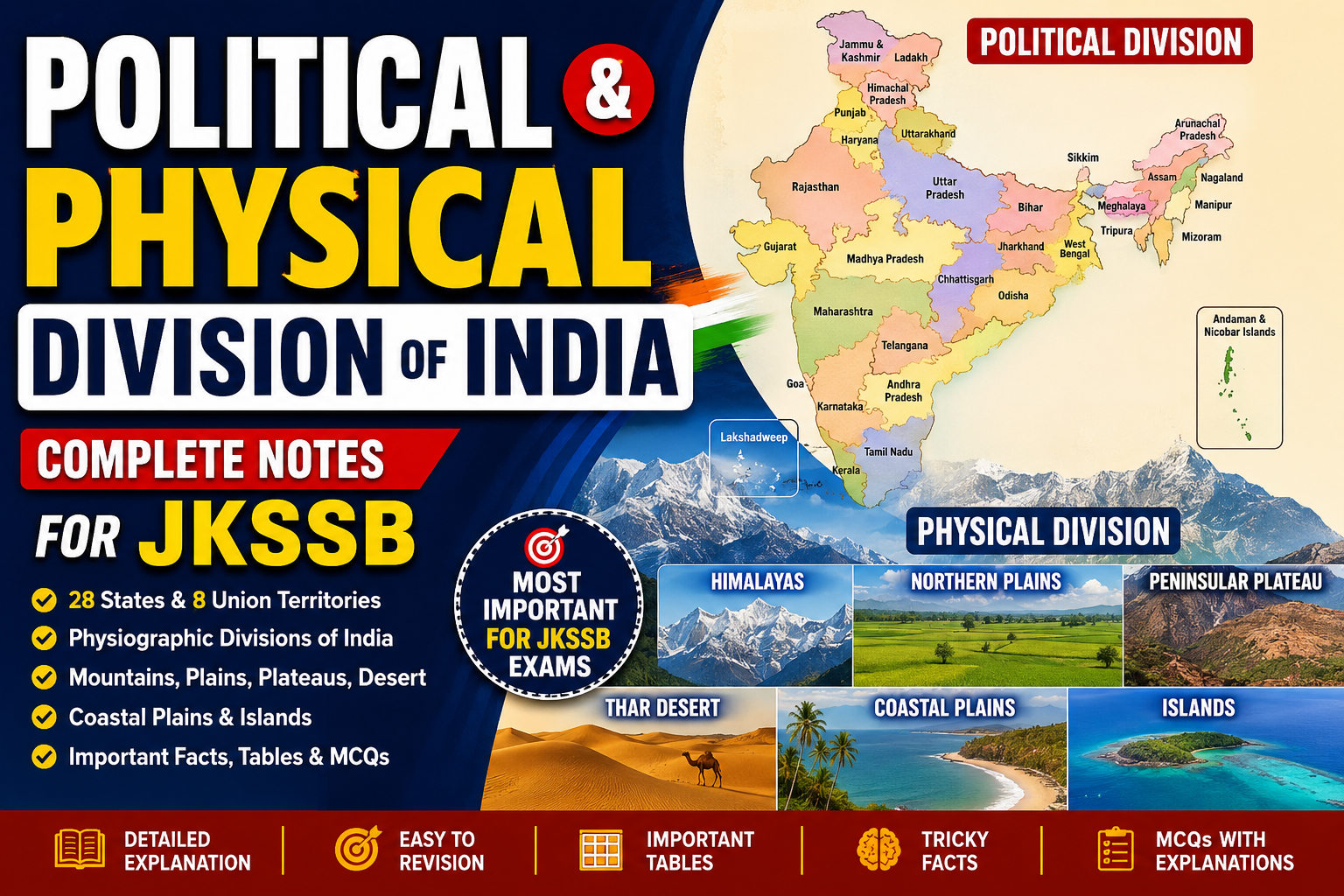
Political and Physical Division of India
Introduction
India is one of the most geographically diverse countries in the world. From the snow-covered Himalayas in the north to the coastal plains of the south, from the fertile Indo-Gangetic plains to the dry Thar Desert, India presents extraordinary physical diversity.
At the same time, politically India is divided into States and Union Territories for administrative convenience and governance. Understanding both the political division and physical division of India is extremely important for JKSSB aspirants because questions are frequently asked from:
- Indian Geography
- Indian Polity
- Mapping sections
- Static GK
- Rivers and Mountains
- States and Capitals
- Borders and Physiographic Divisions
- Natural Resources
- Agriculture and Climate
In JKSSB examinations, many questions are straightforward factual questions, but increasingly examiners also ask conceptual and application-based geography questions. Therefore, understanding “why” a region exists and “how” geography affects climate, agriculture, population, economy, and transport becomes very important.
Understanding Political Division and Physical Division
| Basis | Political Division | Physical Division |
| Meaning | Administrative division made by humans | Natural division formed by nature |
| Example | States and Union Territories | Mountains, Plains, Plateaus |
| Nature | Changes over time | Mostly permanent |
| Purpose | Governance and administration | Natural geographical classification |
| Controlled By | Government and Constitution | Geological and natural processes |
Political Division of India
What is Political Division?
Political division refers to the administrative division of India into:
- States
- Union Territories
- Districts
- Divisions
- Tehsils
These divisions help in administration, governance, law and order, development planning, elections, and implementation of government policies.
India follows a federal system with unitary features, meaning powers are divided between the Centre and States.
Present Political Structure of India
States and Union Territories
India currently has:
| Type | Number |
|---|---|
| States | 28 |
| Union Territories | 8 |
This is one of the most frequently asked factual questions in competitive exams.
Difference Between State and Union Territory
Students often confuse this area.
Quick Concept Summary
| State | Union Territory |
|---|---|
| Has elected government | Directly controlled by Centre |
| Has constitutional powers | Fewer powers |
| Governor is constitutional head | Administrator/LG appointed by President |
| More autonomy | Less autonomy |
| Examples: Punjab, Rajasthan | Ladakh, Chandigarh |
Why Were States Created?
Initially after independence, India inherited provinces and princely states from the British.
But soon demands arose for:
- linguistic identity
- administrative convenience
- cultural recognition
- regional development
Therefore, the States Reorganisation Act, 1956 became a landmark event.
States Reorganisation Act, 1956
This is extremely important for exams.
Background
Initially states were not organized properly on linguistic basis. People demanded states based on language.
The death of Potti Sriramulu after fasting for a Telugu-speaking state forced the government to reconsider state boundaries.
As a result:
- States Reorganisation Commission was formed in 1953.
- Headed by Fazl Ali.
Importance of the States Reorganisation Act
The Act:
- reorganized states mainly on linguistic basis
- simplified administration
- reduced regional tensions
- strengthened Indian unity despite diversity
This is an important conceptual point:
India became stronger not by suppressing linguistic identities but by accommodating them constitutionally.
States and Capitals of India
Complete Revision Table
| State | Capital |
|---|---|
| Andhra Pradesh | Amaravati |
| Arunachal Pradesh | Itanagar |
| Assam | Dispur |
| Bihar | Patna |
| Chhattisgarh | Raipur |
| Goa | Panaji |
| Gujarat | Gandhinagar |
| Haryana | Chandigarh |
| Himachal Pradesh | Shimla |
| Jharkhand | Ranchi |
| Karnataka | Bengaluru |
| Kerala | Thiruvananthapuram |
| Madhya Pradesh | Bhopal |
| Maharashtra | Mumbai |
| Manipur | Imphal |
| Meghalaya | Shillong |
| Mizoram | Aizawl |
| Nagaland | Kohima |
| Odisha | Bhubaneswar |
| Punjab | Chandigarh |
| Rajasthan | Jaipur |
| Sikkim | Gangtok |
| Tamil Nadu | Chennai |
| Telangana | Hyderabad |
| Tripura | Agartala |
| Uttar Pradesh | Lucknow |
| Uttarakhand | Dehradun |
| West Bengal | Kolkata |
Union Territories and Capitals
| Union Territory | Capital |
|---|---|
| Andaman and Nicobar Islands | Port Blair |
| Chandigarh | Chandigarh |
| Dadra and Nagar Haveli and Daman and Diu | Daman |
| Delhi (NCT) | New Delhi |
| Jammu and Kashmir | Srinagar (Summer), Jammu (Winter) |
| Ladakh | Leh |
| Lakshadweep | Kavaratti |
| Puducherry | Puducherry |
Students Often Confuse
| Confusing Pair | Correct Understanding |
|---|---|
| Delhi vs New Delhi | Delhi is NCT; New Delhi is capital area |
| J&K vs Ladakh | Separate UTs since 2019 |
| Chandigarh | Capital of both Punjab and Haryana |
| Hyderabad | Shared capital earlier after Telangana formation |
Formation of Jammu & Kashmir and Ladakh UTs
This area is highly important for JKSSB aspirants.
Reorganisation of 2019
On 31 October 2019:
- Jammu & Kashmir Reorganisation Act came into effect.
- Former state was divided into:
- Union Territory of Jammu & Kashmir
- Union Territory of Ladakh
Key Difference
| Jammu & Kashmir UT | Ladakh UT |
|---|---|
| Has legislature | No legislature |
| LG is administrator | LG is administrator |
| More administrative powers | Directly controlled largely by Centre |
Largest and Smallest States
Area-wise
| Category | State |
|---|---|
| Largest State | Rajasthan |
| Smallest State | Goa |
Population-wise
| Category | State |
|---|---|
| Most Populous | Uttar Pradesh |
| Least Populous | Sikkim |
Physical Division of India
Now we move toward one of the most important geography sections for JKSSB.
What is Physical Division?
Physical division means natural geographical regions formed due to:
- tectonic activity
- geological history
- erosion
- deposition
- volcanic activity
- river action
India is divided into six major physiographic divisions.
Major Physiographic Divisions of India
| Division | Main Feature |
|---|---|
| Northern Mountains | Himalayas |
| Northern Plains | Fertile alluvial plains |
| Peninsular Plateau | Ancient hard rocks |
| Indian Desert | Arid region |
| Coastal Plains | Narrow coastal belts |
| Islands | Andaman-Nicobar and Lakshadweep |
The Himalayan Mountains
The Himalayas are the most important mountain system of India.
The word “Himalaya” means:
- Hima = Snow
- Alaya = Abode
Hence:
“Abode of Snow.”
Formation of Himalayas
This is conceptually important.
Geological Formation
The Himalayas are young fold mountains formed due to collision between:
- Indian Plate
- Eurasian Plate
Millions of years ago:
- Tethys Sea existed between these plates.
- Indian Plate moved northward.
- Sediments got compressed and folded.
- Himalayas were formed.
This is why Himalayas are still rising and highly earthquake-prone.
Why Himalayas are Called Young Fold Mountains
| Feature | Explanation |
|---|---|
| Young | Formed relatively recently |
| Fold Mountains | Rocks folded due to tectonic pressure |
| Unstable | Frequent earthquakes and landslides |
| High Peaks | Includes Mount Everest and Kanchenjunga |
Importance of Himalayas
This is frequently asked conceptually.
Climatic Importance
The Himalayas:
- stop cold winds from Central Asia
- help in monsoon rainfall
- influence Indian climate enormously
Without Himalayas:
India would have been much colder and drier.
River Importance
Most perennial rivers originate from Himalayas:
- Ganga
- Yamuna
- Brahmaputra
- Indus
Glaciers provide year-round water supply.
Strategic Importance
The Himalayas form a natural boundary with:
- China
- Nepal
- Bhutan
Important passes and military locations are located here.
Divisions of Himalayas
Based on Longitudinal Extent
| Division | Location |
|---|---|
| Punjab Himalaya | Indus to Sutlej |
| Kumaon Himalaya | Sutlej to Kali |
| Nepal Himalaya | Kali to Teesta |
| Assam Himalaya | Teesta to Dihang |
Based on Height
| Division | Features |
|---|---|
| Himadri | Highest range |
| Himachal | Lesser Himalayas |
| Shiwalik | Outer Himalayas |
Himadri (Greater Himalayas)
Key Features
- Highest Himalayan range
- Permanently snow-covered
- Average height above 6000 m
- Contains major peaks
Important Peaks
| Peak | Location |
|---|---|
| Kanchenjunga | Sikkim |
| Nanga Parbat | Western Himalayas |
| Nanda Devi | Uttarakhand |
Himachal (Lesser Himalayas)
This region contains:
- valleys
- hill stations
- forests
Important hill stations:
- Shimla
- Mussoorie
- Nainital
Shiwalik Range
The outermost Himalayan range.
Important Features
| Feature | Description |
|---|---|
| Lowest range | Compared to others |
| Loose sediments | Easily eroded |
| Duns | Long valleys like Dehradun |
Important Himalayan Passes
Highly important for exams.
| Pass | Location | Importance |
|---|---|---|
| Zojila Pass | J&K | Connects Kashmir with Ladakh |
| Banihal Pass | J&K | Important road connectivity |
| Nathula Pass | Sikkim | Trade with China |
| Shipki La | Himachal Pradesh | India-China route |
| Bomdi La | Arunachal Pradesh | Strategic importance |
JKSSB Special Focus – Himalayan Region of Jammu & Kashmir
Jammu & Kashmir has:
- Pir Panjal Range
- Greater Himalayas
- Karewas
- Glaciers
- Valleys
Karewas
Very important for JKSSB.
What are Karewas?
Karewas are thick deposits of:
- clay
- silt
- sand
Found mainly in:
- Kashmir Valley
Importance of Karewas
| Importance | Explanation |
|---|---|
| Agriculture | Saffron cultivation |
| Horticulture | Almond and walnut |
| Geological importance | Evidence of ancient lake deposits |
Northern Plains of India
The Northern Plains are formed by:
- Indus River system
- Ganga River system
- Brahmaputra River system
These plains are among the most fertile regions in the world.
Formation of Northern Plains
The plains were formed due to:
- deposition of alluvium by rivers
- sediment accumulation over thousands of years
Importance of Northern Plains
| Importance | Explanation |
|---|---|
| Agriculture | Highly fertile soil |
| Dense population | Water availability |
| Transport | Flat terrain |
| Civilization | Ancient civilizations flourished |
Types of Northern Plains Soil Regions
| Region | Meaning |
|---|---|
| Bhabar | Pebble deposits |
| Terai | Marshy belt |
| Bhangar | Old alluvium |
| Khadar | New alluvium |
Students Often Confuse
| Term | Confused With | Correct Idea |
|---|---|---|
| Bhangar | Khadar | Old alluvium |
| Khadar | Bhangar | New fertile alluvium |
| Terai | Bhabar | Marshy zone |
Peninsular Plateau
The Peninsular Plateau is one of the oldest landmasses of Earth.
Unlike Himalayas:
- it is stable
- made of igneous and metamorphic rocks
- rich in minerals
Divisions of Peninsular Plateau
| Division | Features |
|---|---|
| Central Highlands | North of Narmada |
| Deccan Plateau | South of Narmada |
Deccan Plateau
Important Features
| Feature | Description |
|---|---|
| Shape | Triangular |
| Rivers | Godavari, Krishna, Kaveri |
| Rocks | Basaltic lava |
| Soil | Black soil |
Black Soil
Why Important?
Black soil is ideal for:
- cotton cultivation
Hence:
called “Black Cotton Soil.”
Western Ghats and Eastern Ghats
| Western Ghats | Eastern Ghats |
|---|---|
| Continuous | Discontinuous |
| Higher | Lower |
| Heavy rainfall | Less rainfall |
| Rich biodiversity | Comparatively lower biodiversity |
Indian Desert
Thar Desert
Located mainly in:
- Rajasthan
Characteristics
| Feature | Description |
|---|---|
| Rainfall | Very low |
| Vegetation | Thorny bushes |
| Population | Sparse |
| River | Luni River |
Why Desert Forms Here
Students should understand conceptually.
Reasons:
- Aravalli Range parallel to monsoon direction
- Distance from sea
- Dry continental climate
Coastal Plains of India
India has long coastline of about:
7,500 km (including islands).
Western Coastal Plains
| Region | Location |
|---|---|
| Konkan Coast | Maharashtra-Goa |
| Kannad Coast | Karnataka |
| Malabar Coast | Kerala |
Eastern Coastal Plains
| Region | Location |
|---|---|
| Northern Circars | Andhra Pradesh |
| Coromandel Coast | Tamil Nadu |
Difference Between Western and Eastern Coastal Plains
| Western Coastal Plains | Eastern Coastal Plains |
|---|---|
| Narrow | Wider |
| More ports | Large deltas |
| Rivers form estuaries | Rivers form deltas |
Islands of India
India has two major island groups.
| Island Group | Location |
|---|---|
| Andaman & Nicobar Islands | Bay of Bengal |
| Lakshadweep Islands | Arabian Sea |
Andaman and Nicobar Islands
Important Facts
| Feature | Description |
|---|---|
| Origin | Mostly volcanic |
| Highest Point | Saddle Peak |
| Active Volcano | Barren Island |
Lakshadweep Islands
Important Features
| Feature | Description |
|---|---|
| Origin | Coral islands |
| Sea | Arabian Sea |
| Capital | Kavaratti |
Quick Revision Block
| Topic | Key Point |
|---|---|
| Himalayas | Young fold mountains |
| Northern Plains | Alluvial fertile plains |
| Peninsular Plateau | Old stable landmass |
| Thar Desert | Arid western region |
| Coastal Plains | Narrow coastal belts |
| Islands | Coral and volcanic origin |
Most Important One-Liners for JKSSB
- India has 28 States and 8 Union Territories.
- Rajasthan is the largest state by area.
- Goa is the smallest state by area.
- Himalayas are young fold mountains.
- Northern Plains are formed by river deposition.
- Peninsular Plateau is rich in minerals.
- Black soil is ideal for cotton.
- Barren Island is India’s active volcano.
- Lakshadweep islands are coral islands.
- Khadar is newer alluvium.
Memory Tricks
Himalayan Divisions
Himadri → Highest
Himachal → Hill stations
Shiwalik → Small outer hills
Students Often Make These Mistakes
| Mistake | Correct Understanding |
|---|---|
| Thinking Himalayas are old mountains | They are young fold mountains |
| Confusing Bhangar and Khadar | Khadar is newer |
| Thinking Lakshadweep volcanic | Coral origin |
| Confusing Eastern and Western Ghats | Western Ghats are continuous |
JKSSB MCQs with Explanations
1. Which is the largest state of India by area?
A. Maharashtra
B. Madhya Pradesh
C. Rajasthan
D. Uttar Pradesh
Answer: C. Rajasthan
Explanation: Rajasthan is the largest Indian state by geographical area.
2. The Himalayas are an example of:
A. Block Mountains
B. Residual Mountains
C. Young Fold Mountains
D. Volcanic Mountains
Answer: C. Young Fold Mountains
Explanation: Himalayas were formed by folding due to collision of tectonic plates.
3. Which soil is most suitable for cotton cultivation?
A. Red Soil
B. Black Soil
C. Laterite Soil
D. Alluvial Soil
Answer: B. Black Soil
Explanation: Black soil retains moisture and is ideal for cotton farming.
4. Which river forms the Northern Plains?
A. Narmada
B. Tapi
C. Indus-Ganga-Brahmaputra systems
D. Godavari
Answer: C. Indus-Ganga-Brahmaputra systems
5. Which island group lies in the Arabian Sea?
A. Andaman Islands
B. Nicobar Islands
C. Lakshadweep
D. Sriharikota
Answer: C. Lakshadweep
6. Karewas are famous for cultivation of:
A. Tea
B. Coffee
C. Saffron
D. Rubber
Answer: C. Saffron
7. Which coastal plain is associated with Kerala?
A. Coromandel Coast
B. Northern Circars
C. Konkan Coast
D. Malabar Coast
Answer: D. Malabar Coast
Frequently Asked Questions (FAQs)
What are the six physical divisions of India?
India is divided into:
- Himalayas
- Northern Plains
- Peninsular Plateau
- Indian Desert
- Coastal Plains
- Islands
Why are Northern Plains fertile?
Northern Plains are fertile because rivers deposit nutrient-rich alluvial soil.
Which is the active volcano of India?
Barren Island in Andaman and Nicobar Islands is the active volcano of India.
Why are Himalayas important?
Himalayas influence climate, provide rivers, protect India strategically, and support biodiversity.
Final Revision Summary
| Topic | Important Point |
|---|---|
| Political Division | 28 States and 8 UTs |
| Largest State | Rajasthan |
| Smallest State | Goa |
| Himalayas | Young fold mountains |
| Plains | Formed by river deposition |
| Plateau | Mineral-rich ancient land |
| Desert | Thar Desert in Rajasthan |
| Coastal Plains | Eastern wider than western |
| Islands | Lakshadweep coral islands |
Final Educational Observation
Students preparing for JKSSB should not study Indian Geography as isolated facts only. The examiner increasingly connects:
- geography with agriculture
- geography with climate
- geography with economy
- geography with environment
- geography with strategic importance
For example:
- Himalayas are not important only because they are mountains.
- They influence monsoon, rivers, defense, tourism, hydropower, biodiversity, and even population distribution.
Similarly:
- Northern Plains are not just fertile regions.
- They became centers of civilization because rivers supported agriculture, transport, trade, and urbanization.
When students understand these interconnections, geography becomes easier, more logical, and far more scoring in exams.